Local Fire History

Yucaipa Wildfire History: From the El Dorado Fire to Today

Yucaipa sits at the western mouth of one of California's most fire-prone wind corridors. Its modern history is shaped by three major fires — the 2003 Old Fire, the 2020 Apple Fire, and the 2020 El Dorado Fire — that explain why every property in the Yucaipa Valley faces mandatory defensible space requirements today.

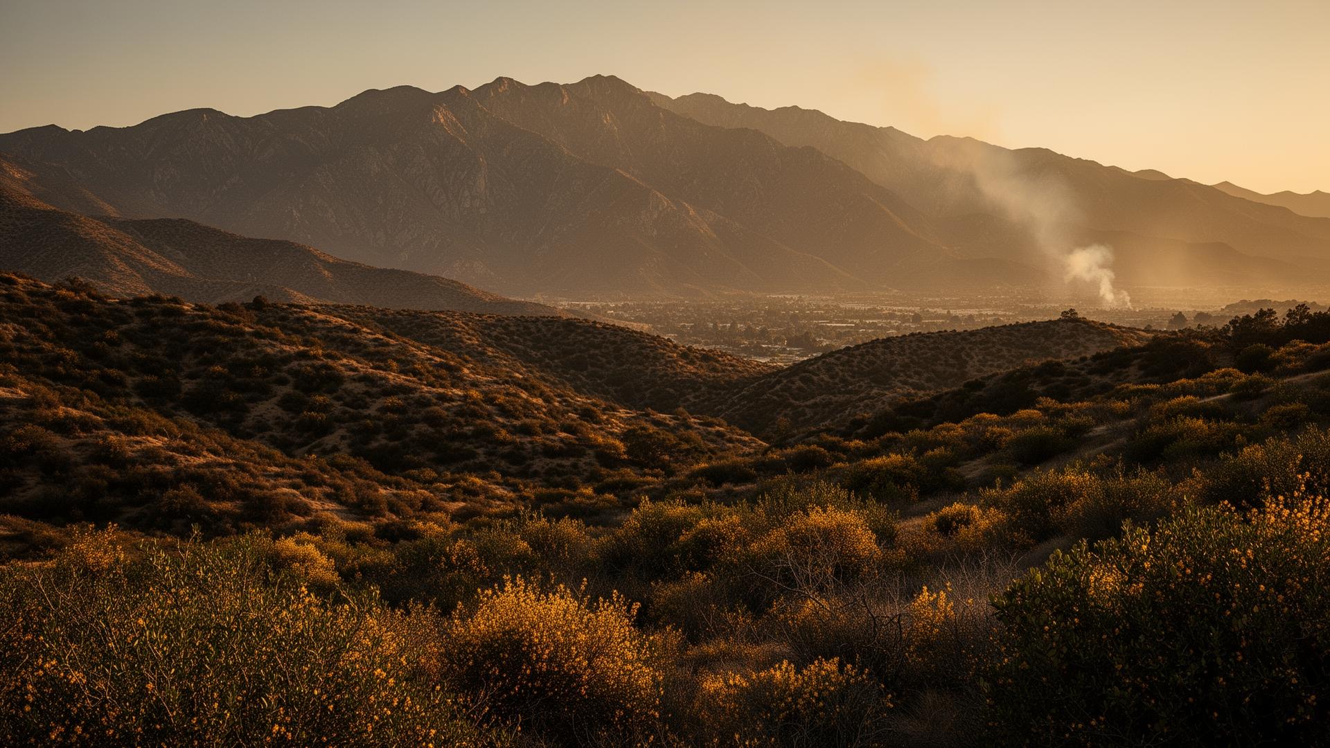
Yucaipa Valley foothills and the San Bernardino Mountains at sunset, with chaparral terrain and faint smoke on the horizon — the landscape shaped by the 2003 Old Fire, 2020 Apple Fire, and 2020 El Dorado Fire.
The Yucaipa Valley sits at the foot of the San Bernardino Mountains — chaparral, slope, and Santa Ana winds combine here.

Last updated: May 20, 2026

Why Yucaipa's fire history matters

If you own property in Yucaipa or anywhere in the San Bernardino County foothills, the wildfires of the past two decades aren't ancient history. They're the reason your property has annual defensible space requirements, the reason your insurance carrier asks specific questions, and the reason CAL FIRE inspectors arrive each fire season.

This guide walks through the three fires that defined Yucaipa's modern risk profile — what happened, why it happened, and what it means for your property today. The patterns are consistent. Steep foothill terrain. Dense chaparral. Santa Ana winds funneling through the San Gorgonio Pass. Long, hot summers that dry vegetation to tinder.

Understanding this history is the difference between treating defensible space as bureaucratic annoyance and treating it as what it actually is: the most effective property-level protection available.
Timeline

Three fires that shaped the Yucaipa Valley

Oct 2003

The Old Fire

Acres burned
91,281
Structures lost
993
Fatalities
6
Cause
Arson

The Old Fire began on October 25, 2003 near Old Waterman Canyon Road in the San Bernardino Mountains, just north of the city of San Bernardino. (CAL FIRE)

Driven by powerful Santa Ana winds, the fire destroyed 993 homes and caused six deaths over an eight-day period. It threatened San Bernardino, Highland, and the mountain communities of Cedar Glen, Crestline, Running Springs, and Lake Arrowhead — forcing the evacuation of an estimated 80,000 residents.

The Old Fire was deliberately set. A San Bernardino County jury later convicted Rickie Lee Fowler of five counts of murder and two counts of arson, sentencing him to death in 2012.

The lesson from the Old Fire wasn't just about arson risk. It was about how fast a fire driven by Santa Ana winds can move through chaparral and into populated foothill neighborhoods. That dynamic — wind, slope, dry fuel, populated foothills — applies directly to Yucaipa.

Jul 2020

The Apple Fire

Acres burned
33,424
Evacuations
~8,000
Counties
Riverside / SB
Cause
Human-related

The Apple Fire ignited on July 31, 2020 in Cherry Valley, just south of Yucaipa in Riverside County. (CAL FIRE incident page)

The fire eventually burned across Riverside County and into the San Bernardino National Forest, threatening Beaumont, Banning, and the southern flanks of the San Bernardino Mountains. Investigators classified the cause as human-related. Nearly 8,000 people were placed under evacuation orders.

For Yucaipa Valley residents, the Apple Fire was a clear warning. It burned along the southern edge of the same mountain range that protects (and threatens) Yucaipa from the north. The smoke column was visible from across the Inland Empire. Evacuation infrastructure was tested. Properties just miles from Yucaipa were affected directly.

Sep 2020

The El Dorado Fire

Acres burned
22,744
Structures lost
20
Firefighter killed
Charles Morton
Cause
Smoke device

Five weeks after the Apple Fire was contained, the El Dorado Fire began at El Dorado Ranch Park near Yucaipa on September 5, 2020. (CAL FIRE incident page)

The fire burned 22,744 acres over 71 days, spreading from El Dorado Ranch Park north into the San Gorgonio Wilderness Area of the San Bernardino National Forest. It destroyed 20 structures, injured 13 civilians, and forced evacuations across north Yucaipa, Oak Glen, Mountain Home Village, Forest Falls, and Angelus Oaks.

On September 17, 2020, U.S. Forest Service firefighter Charles Morton — a squad boss with the Big Bear Hotshots and an 18-year veteran — was killed near Jenks Lake while engaged in fire suppression.

Morton was 39. He left behind a wife and daughter. The Jimenez couple were later charged with involuntary manslaughter and pleaded guilty in 2024. The case became a national story about the consequences of routine carelessness in fire-prone terrain.

Geography

Why Yucaipa burns

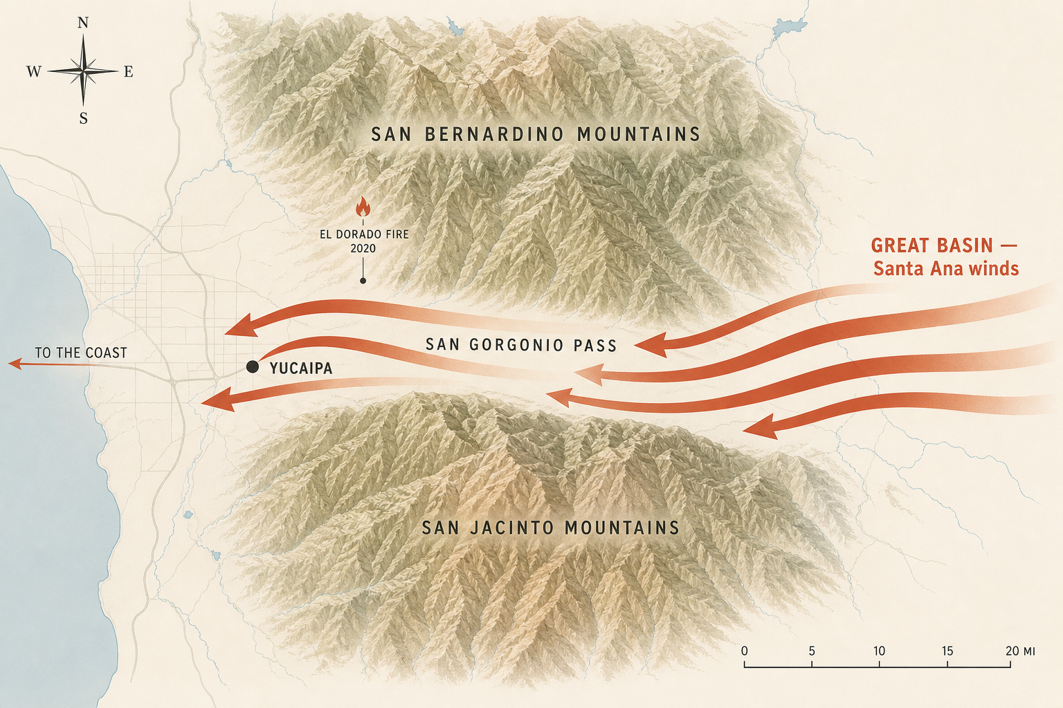
Map diagram of the San Gorgonio Pass wind corridor between the San Bernardino Mountains and the San Jacinto Mountains, showing Santa Ana winds from the Great Basin flowing west through Yucaipa toward the Pacific coast, with the 2020 El Dorado Fire ignition point marked north of Yucaipa.
The San Gorgonio Pass funnels Santa Ana winds from the Great Basin straight across Yucaipa toward the coast.

Three of California's most powerful fire factors converge in the Yucaipa Valley.

Foothill chaparral. Yucaipa sits at the transition between flat valley floor and steep mountain terrain. The vegetation in this zone — chamise, manzanita, scrub oak, and grasses — is exactly the fuel profile that produces high-intensity wildfire. Chaparral evolved with fire. It burns hot, fast, and clean.

Santa Ana wind alignment. The San Gorgonio Pass between the San Bernardino Mountains and the San Jacinto Mountains is a major Santa Ana wind corridor. When high pressure builds over the Great Basin during late summer and fall, hot dry air accelerates through this gap toward the coast. Yucaipa sits directly in the path. Wind speeds of 50–70 mph are not unusual.

Slope and fuel loading. The terrain north and east of Yucaipa rises sharply into mountain elevations. Fire moves uphill faster than it moves on flat ground — much faster. Combined with decades of fuel accumulation in the San Bernardino National Forest, a Yucaipa-area ignition can become a major fire within hours.

These factors don't change. They are the geographic reality of where Yucaipa is built. What does change is how individual properties prepare for them.

What it means today

What this history means for your property

Yucaipa's fire history is the reason every property in the area is subject to specific legal and practical requirements today.

Defensible space is mandatory

Under California Public Resources Code 4291, every property in a fire hazard zone must maintain 100 feet of defensible space around structures. Yucaipa falls within Fire Hazard Severity Zones designated by CAL FIRE, which means PRC 4291 applies. CAL FIRE conducts annual inspections during fire season. Properties that fail inspection receive a 30-day notice to comply.

County abatement runs in parallel

The San Bernardino County Fire Hazard Abatement Program operates under County Code 23.0301–23.0319 and conducts its own inspections in Yucaipa (which contracts with the County for fire abatement services). The County's program issues separate Notice and Order to Abate documents with their own 30-day compliance windows.

If you received a notice from either CAL FIRE or the County, see our CAL FIRE Notice guide or our County Abatement Notice guide.

Insurance carriers are watching

Major insurance carriers have aggressively retrenched from high-risk California areas since 2023. State Farm, Allstate, Farmers, Travelers, Chubb, Nationwide, and USAA have all reduced or paused new policy issuance in similar markets. (Insurance.com)

Yucaipa properties are increasingly being asked to document defensible space and home hardening work as a condition of policy renewal. See California Insurance Non-Renewal: What Homeowners Should Know for the current landscape.

Zone 0 enforcement is coming

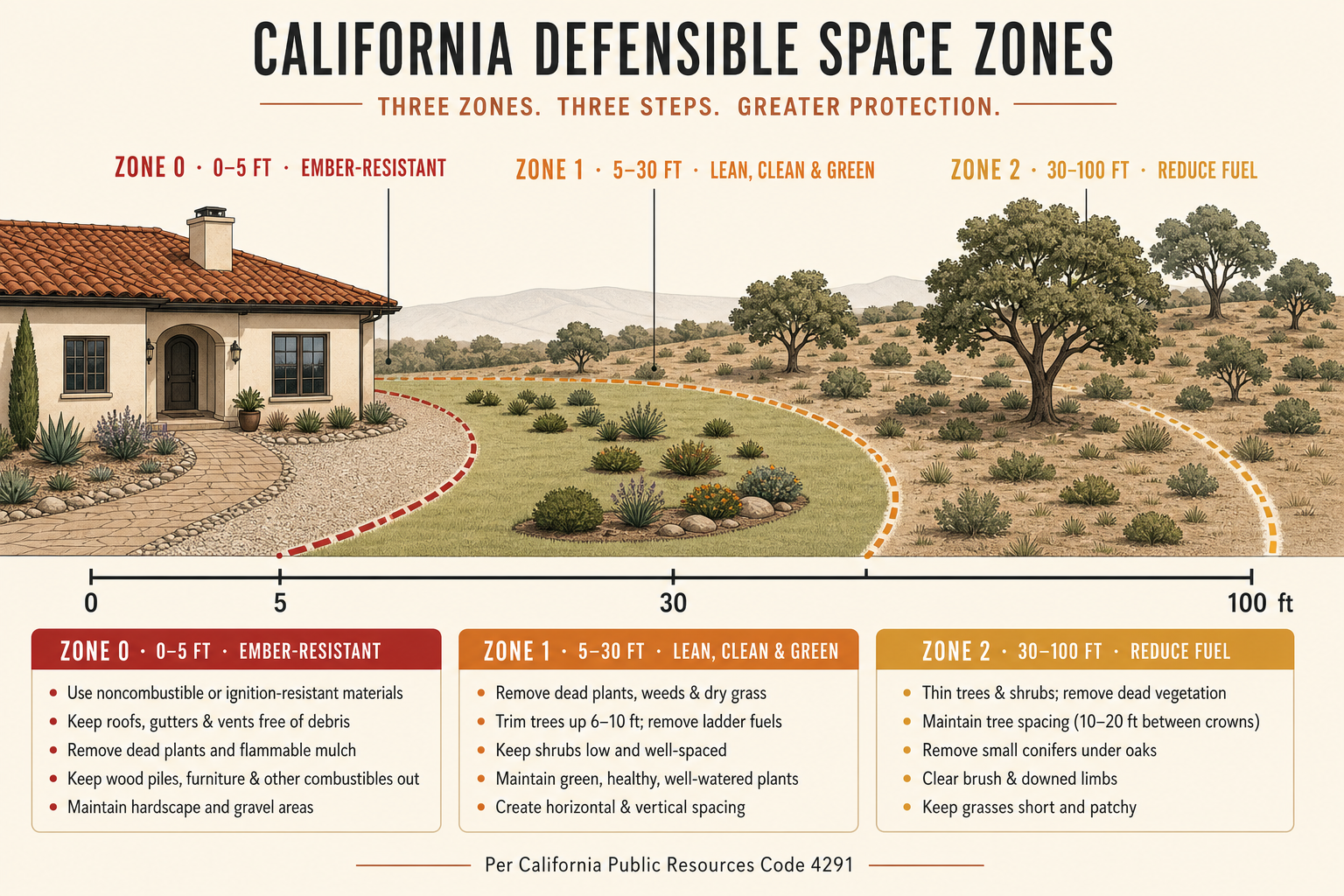
Under AB 3074, the first 5 feet around any structure in a fire hazard severity zone must be ember-resistant — no combustible mulch, no flammable plants, no wood fences attaching to the structure. Enforcement begins for existing structures in Very High Fire Hazard Severity Zones in 2027. Yucaipa properties fall within enforcement scope.

Diagram of California defensible space zones around a home: Zone 0 (0–5 ft ember-resistant), Zone 1 (5–30 ft lean and clean), and Zone 2 (30–100 ft reduced fuel), as required by PRC 4291 and AB 3074.
California's three defensible space zones: Zone 0 (0–5 ft), Zone 1 (5–30 ft), Zone 2 (30–100 ft).

For deeper coverage of the AB 3074 timeline, see AB 3074 Explained.

Action plan

What Yucaipa homeowners should do now

Based on the fire history and current regulatory landscape, here's what makes sense for most Yucaipa-area properties:

  1. Schedule a defensible space assessment. A free walkthrough from a vetted contractor identifies specific gaps before CAL FIRE or the County does. See Property Fire Assessment.
  2. Address Zone 1 vegetation issues. Most properties have at least one ladder fuel, one dead tree branch, or one section of overgrown brush that would fail inspection. See Defensible Space Clearing.
  3. Begin Zone 0 planning before 2027 enforcement. Properties that address the ember-resistant 5-foot perimeter early avoid the rush as enforcement approaches. See Zone 0 Compliance.
  4. Document your work. Photos, written contractor reports, and dated receipts support both insurance renewal and future property sales under AB 38 disclosure requirements.
  5. Consider annual maintenance. Recurring service is typically less expensive than emergency compliance work after a notice arrives. See Annual Maintenance.

Nearby risk

The broader Yucaipa Valley risk landscape

Yucaipa's fire profile is shared by neighboring foothill and mountain communities. Each carries its own version of the same fundamental geography.

Mentone sits directly east of Yucaipa along the State Route 38 corridor leading into the San Bernardino Mountains. Its proximity to the National Forest creates similar wildfire exposure.

Forest Falls is a mountain community within the San Bernardino National Forest itself. It evacuated during the El Dorado Fire and faces some of the highest fire risk levels in San Bernardino County.

Calimesa — just south of Yucaipa across the Riverside County line — suffered the 2019 Sandalwood Fire that destroyed 76 structures and killed two residents. Calimesa's experience underscores that fire risk in this region isn't theoretical.

Highland, Redlands, and Mentone all share the same wildland-urban interface profile that makes annual defensible space work non-optional.

FAQ

Frequently asked questions

Get Your Free Defensible Space Estimate

Wildfire season doesn't wait. Call now or request a free on-site assessment from a licensed San Bernardino County contractor.